GNSS and mobility: innovation in motion at ITS Singapore

Connected and Automated Mobility is poised to transform the movement of people and goods, vehicle ownership and mobility services. Recent technological leaps are rapidly bringing us closer to this new frontier, making transportation safer, more accessible and sustainable. At the ITS World Congress in Singapore, European GNSS Agency (GSA) Executive Director Carlo des Dorides stressed the central role of GNSS in the Connected and Automated Mobility ecosystem.
Positioning is needed everywhere, but it is the area of Connected and Autonomous Vehicles (CAV) that presents the highest challenges in term of performance. Speaking at a congress plenary session on Advancing Connected and Automated Mobility Deployment on 22 October, the GSA Executive Director said that, thanks to new powerful GNSS signals, such as those provided by the Galileo High Accuracy Service, the industry would be able to offer decimetre-level absolute positioning at a low cost, functioning seamlessly in challenging environments such as deep urban canyons and in low visibility weather conditions.
Paradigm change
With regard to mobility, he noted that Mobility as a Service, for example, would bring about a paradigm change in transportation, made possible by the simultaneous availability of multiple technologies, including satellite-enabled location based services. “Moreover, autonomous vehicles will soon be a reality and we are already working to demonstrate the great potential of EGNOS and Galileo in this area, together with other on-board sensors,” he said, adding that Galileo is the only constellation that will provide authentication of the satellite navigation signal.
Read this: Save the Date: Live demo of first Galileo-enabled autonomous vehicle
“In ITS, Horizon 2020 is helping to showcase the full potential of advanced satellite positioning for autonomous vehicles, based on integrated solutions that need to start from low-level signal processing to high-level data fusion in order to get a continuous and reliable positioning,” he said. He also noted that the GSA´s Fundamental Elements programme was funding the development of an E-GNSS engine to provide precise location to critical applications and to a set of diverse in-vehicle applications that improve passenger comfort and make mobility smarter.
Two pillars
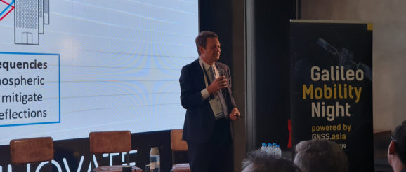
At Galileo Mobility Night, a panel discussion at the ITS World Congress organised by GNSS.asia later the same day, des Dorides told participants that GNSS is currently structured around two pillars – the multi-constellation concept and the multi-frequency concept. “Recent developments in technology mean that our devices and handsets can be compatible with three or ever four constellations, which means that our smartphones can choose the best combination of satellites to compute our positioning,” he said.
And this: European GNSS supports smarter mobility
Stressing that Galileo is the only GNSS constellation in which all satellites have multi-frequency capability, he went on to say that multi-frequency means better accuracy, as using two frequencies makes it easier to correct ionospheric errors and mitigate multipath reflections in urban canyons.
Also speaking at Galileo Mobility Night, Dr Johanna Tzanidaki from ERTICO-ITS Europe outlined some of the areas where Galileo’s accuracy is critical. These include automated driving, urban air mobility (drones), logistics, road pricing and congestion charging. “Galileo is also very important in the development of HD maps, and HD maps are the key to automated and autonomous driving, she said.
Media note: This feature can be republished without charge provided the European GNSS Agency (GSA) is acknowledged as the source at the top or the bottom of the story. You must request permission before you use any of the photographs on the site. If you republish, we would be grateful if you could link back to the GSA website (http://www.gsa.europa.eu).
