How 3D scanning drives innovation in facility and asset management

Italy’s market leader for facility and asset management solutions, Geomap, is taking advantage of NavVis’ advanced indoor spatial intelligence technology to push facility management into exciting new territory. Today, we wanted to share the company’s innovative solution with you, starting with how they are using 3D scanning to drive innovation.
Geomap started providing asset and facilities management solutions over 20 years ago and today it services over 3,000 buildings, including airports, hospitals, and universities, for a roster of some 250 partners. The firm works mostly for property owners, or sometimes tenants, to develop solutions based on its dedicated software Information System, which has been developed continuously over the past 15 years.
As Andrea Paglialunga, Business Development Manager at Geomap told me during a recent interview: “The Information System helps companies reduce the cost of their maintenance activities; we have estimated a company using our software can cut maintenance costs by seven percent within five years compared to having no system in place.”
The system is configured to manage each property, building system, and technical components using data sheets that contain all relevant information on things like the position of assets, maintenance plans, maintenance activities performed and related documents.
Accurate survey data means reliable facility management data
 NavVis IMMS in action during a scanning process, simultaneously taking high-resolution panoramic images and capturing point cloud data
Surveying activities are vital to ensure that the Information System is populated with detailed and reliable information on all the key assets in a building, covering critical heating and cooling, safety and other systems.
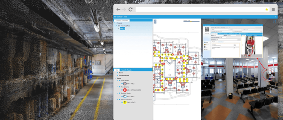
Where previously, Geomap relied on in-house surveying technology, today it deploys the NavVis indoor mobile mapping system (IMMS), which automatically captures large indoor environments as both 360° panoramic images and point clouds. The 360° images are displayed using NavVis IndoorViewer software and the point clouds are used to generate accurate floorplans. Both IndoorViewer and accurate floorplans are fully integrated into and accessible via Geomap’s Information System.
Adopting the use of a mobile 3D scanning device has significantly driven innovation in what was once an expensive and time-consuming task. The NavVis IMMS is able to frequently capture data to ensure that everything is accurate and up to date. “In the past, surveying a 20,000 square meter building took three surveyors around seven days and could only focus on the assets that were most important for facility managment activities. Now it takes one guy just eight to nine hours and he can map 100% of the building,” said Paglialunga.
Point cloud-based floorplans are accurate to reality and replace out of date 2D drawings often used by facility management teams. They can be used to take accurate measurements and some Geomap clients have used them as the basis for a Building Information Model, which is more accurate than building a 3D model from scratch without survey data.
Building a custom solution
Geomap has developed a custom solution for facility management using NavVis 3D scanning tech. First, if the NavVis IMMS is unable to easily ‘see’ information written on the surface of an asset because it is concealed from view, clever technical wizardry makes it possible to enhance the survey data with specific technical asset information. This is a valuable feature for asset management.
Another building management specific development is the asset documentation feature Geomap has developed. With this innovative feature, when the surveyor passes by an object considered important for maintenance activities during a scan they simply take out an iPad to capture a photo, and then note down the brand, serial number, and last maintenance activity performed. This data is automatically geo-referenced to the position of the NavVis IMMS and once back at the office, synced with the Information system.
3D scanning is only the beginning of Geomap’s drive to innovate facility and asset management. Check back next time to find out how Geomap is transforming communication with building occupants using NavVis IndoorViewer software.
