Ford Is Sharing Its Self-Driving Car Data To Spur Innovation | Carscoops

Ford is releasing data from multiple self-driving research vehicles in an attempt to spur innovation in the field of autonomous research.
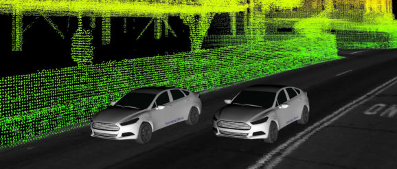
The dataset is aimed at the entire academic community, and includes not just LiDAR and camera sensor data, plus GPS and trajectory information, but also unique elements such as multi-vehicle data and 3D point cloud and ground reflective maps.
This dataset spans an entire year and includes seasonal variations and different types of environments throughout Metro Detroit – sunny, cloudy and snowy days, freeways, tunnels, residential complexes and neighborhoods, airports, dense urban areas, as well as construction zones and pedestrian activity.
“Most datasets only offer data from a single vehicle, but sensor information from two vehicles can help researchers explore entirely new scenarios, especially when the two encounter each other at different points along their respective routes. Right now, one vehicle has limited “vision” in terms of what it can see; you’ll note in our visualizations that some parts are not colored in, which is because the vehicle’s sensors could not penetrate those areas. But with multiple vehicles in the same general area, it’s feasible one would detect things the others simply cannot, potentially opening up new routes for multi-vehicle communication, localization, perception and path planning.”
With that in mind, the set includes high-res time-stamped data from a total of four LiDAR and seven cameras. Meanwhile, precise localization and ground truth data allows researchers to see just how accurate their algorithms are.
In addition to all of this, Ford is also giving the research community access to high-res 3D ground plane reflectivity maps, giving us an understanding of how these self-driving vehicles “see” the world around them.
The first set of data logs can be accessed here, with the U.S. carmaker continuing to update the site until all of its logs have been uploaded.
