NASA Lidar Tech Innovation Will Amaze | In the Scan

Like a sonar using light instead of sound, lidar technology increasingly helps NASA lidar scientists and explorers with remote sensing and surveying, mapping, 3D-image scanning, hazard detection and avoidance, and navigation.
From an article by Elizabeth Markham at NASA Goddard.
Cutting edge innovations by NASA researchers seek to refine lidars into smaller, lighter, more versatile tools for exploration.
“There are a lot of flavors of lidar right now,” said Cheryl Gramling, assistant chief for technology at NASA’s Goddard Space Flight Center in Greenbelt, Maryland. “It’s such an important technology because of the precision and versatility that it offers.”
Light detection and ranging, or lidar, is a remote sensing technology related to sonar and radar. Lidar uses pulses of light to measure distances and properties of objects accurately, by measuring the time it takes the light to reflect back to the lidar sensor.
Goddard innovators are looking to expand the usefulness of lidar applications in communication and navigation, planetary exploration, and space operations. Here are a few of the current investigations.
Foldable, Flat Lidar Optics
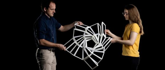
Research engineer Mark Stephen is developing a deployable, segmented telescope to capture the returning light signal using state-of-the-art flat-panel optics organized in foldable, origami-inspired panels. Working with researchers at Brigham Young University, their team seeks to provide future missions with the benefits of lidar technology without the current technologies’ high cost and limited efficiency.
Lidar typically is a high-cost technology that may not make the cut for tomorrow’s smaller, lighter, and more efficient missions. Size, weight, and power demands limit the technology’s ability to be implemented in more missions.
“Most people want really high performance,” Stephen said, “But they want it in a small, light, and power-efficient package. We’re trying to find the best balance, and cost matters. Often the cost comes more from the size, weight, and power than it does from the actual development if we’re launching something into space. That is where it gets expensive.”
Stephen is wrapping up a three-year effort to improve lidars through a Radical Innovation Initiative grant within Goddard’s Internal Research and Development (IRAD) program. Their project has been picked up by NASA’s Earth Science Technology Office to fund further improvements.
For the complete article on NASA lidar innovation CLICK HERE.
Note – If you liked this post click here to stay informed of all of the 3D laser scanning, geomatics, UAS, autonomous vehicle, Lidar News and more. If you have an informative 3D video that you would like us to promote, please forward to editor@lidarnews.com and if you would like to join the Younger Geospatial Professional movement click here
